found this site that teach Japanese using Chinese translation...
http://f3.aaa.livedoor.jp/~taamchai/lang/chinese-language1.html#aisatu
Friday, January 30, 2009
Thursday, January 29, 2009
Tanjung Piai @ Pontian, Johor
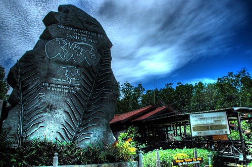


Tanjung Piai stands at the southern-most tip of the Asian continent. "Tanjung" means cape in Malay, and Tanjung Piai derives its names from the "Paku Piai Raya" fern, which flourishes in the area. Besides its geographical fame, Tanjung Piai is also home to Tanjung Piai Johor National Park. If you don’t know where that is, don’t worry.
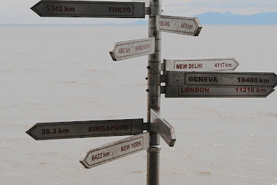
Now imagine standing at the very edge. What an awesome feeling, one that will make the journey south till the road runs out, worth every km of the way.
It is sandwiched between the Tebrau Straits on one side and the Straits of Malacca on the other. From here, you can see Singapore and the Indonesian island of Pulau Karimum.
For a place that’s geographically so intriguing, it’s a pity that Tanjung Piai remains in the backwater of the country’s tourism.
It’s almost never mentioned in tourism promotional brochures and most Malaysians haven’t the faintest idea of its existence.
While stopping over in Benut to ask for directions to Tanjung Piai, I met a middle-aged local who could only muse “Is that so?” when told of the “southern-most” moniker.
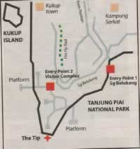
The Muar-Pontian trunk road led me to Sungai Belukang’s entry point and seeing Tanjung Piai from there was a big let-down. It looked dilapidated.
Was this what I drove 10 hours from Ipoh for? I could barely hide my disappointment. But wait a minute. There was another board pointing to “Entry Point 2”. I gave it a shot. And as my car tracked through the narrow, undulating path, I caught sight of a spanking new visitor complex.
Finally, the right place. Johor’s Tanjung Piai National Park covers more than 926 hectares of forest, of which 526 hectares are coastal mangroves with inhabitants that include dusky leaf monkeys, long-tailed macaques, mud-skippers, crustaceans and several rare bird species like the Spoonbilled Sandpiper, Lesser Adjutant Stork and seasonal migratory seabirds. Meandering through the park are concrete paths that lead to observation towers that allow panoramic views of the sea, the coast and the lush forest.
When you walk along these paths, dotted with shelters, you can commune with Mother Nature and the quiet solitude offers peace of mind.

There is little indication that Tanjung Piai lies along the path of one of the busiest shipping corridors in the world and passing vessels create strong waves that erode Tanjung Piai’s mangrove bank by 10m every year.
But all is not lost. In 2003, the Drainage and Irrigation Department embarked on a RM3 million project to install geo-tubes to break incoming waves.
“We are also working with the Pontian District Council to hasten road improvement and to install more signboards with directions to the new complex,” says Harban Singh, Ramsar Site manager for Johor National Park Corporation.
Unfortunately, the soft estuarine soil thwarts efforts to maintain an evenly tarred road. “Ultimately, we want an entry path that’s eco-friendly,” he adds.
Tanjung Piai was recognised by the 1971 Ramsar Conservation signed in Ramsar, Iran, as a wetland of international importance. It was designated a Ramsar Site in 2003, which meant that its ecological character cannot be changed by human activity.
With such protection, let’s hope its natural state will remain, as it would be a pity to lose this sanctuary at Land’s End.
Descendants from Africa?
Greek astronomer Claudius Ptolemy gave the name “Chersonesus Aurea” – meaning The Golden Peninsula – to the Malay Peninsula. It was said that whether one set sail from Europe in the west or China in the east, the ship would end up at Tanjung Piai because monsoon wind from both sides eventually convened on its coastline.
Greek astronomer Claudius Ptolemy gave the name “Chersonesus Aurea” – meaning The Golden Peninsula – to the Malay Peninsula. It was said that whether one set sail from Europe in the west or China in the east, the ship would end up at Tanjung Piai because monsoon wind from both sides eventually convened on its coastline.
What’s more remarkable is that the Tanjung Piai headland has been called the “mother of all dead ends”. Even a nearby village is called Kampung Serkat – a name stemmed from the Malay word sekat, meaning blockage or come to an end.
In May last year, researchers from Leeds and Glasgow University led by Vincent Macaulay, made a startling announcement – that DNA samples taken from the Orang Asli matched a 60,000-year-old African DNA sample. The finding fuelled great interest worldwide.
Homo erectus, who first left Africa, took a single long coastal journey to escape the Ice Age – along Arabian peninsular and India. They stopped at Tanjung Piai when they couldn’t go further as prehistoric man had not learned to sail. This made the Orang Asli in Tanjung Piai an isolated community.
Why Go?
Tanjung Piai offers spectacular views and a holiday romp with a bit of everything – nature, captivating facts, history, and oh yes, great seafood.
While not many of us will have the opportunity to go to the North or South Poles, we can definitely get to Tanjung Piai which is right in our own backyard.
What To Do
Slowly soak in the wonders of Tanjung Piai’s mangroves. With the raised boardwalk network that runs through the mangroves, there’s no excuse not to.
There are maps and ample directional signages. You can camp, go on night walks and observe the wetlands wildlife in the dark.For RM5, you can get a certificate at the park complex that says you’ve reached Asia’s southern-most tip. You can also pick up hip T-shirts with interesting graphics of mangrove roots.
There are two entry points to Tanjung Piai - the one at Sungai Belukang and the other at Desa Sri Piai. Entry into the Tanjung Piai park requires a minimal fee of just RM3 for adults (Malaysians) and RM5 for foreign visitors, payable at Tanjung Piai's visitor's complex
If you have the time, go to nearby Kukup Island – the world’s second largest mangrove island (another fact that’s sorely missing in Malaysia’s eco-tourism promotion pages).
If you have the time, go to nearby Kukup Island – the world’s second largest mangrove island (another fact that’s sorely missing in Malaysia’s eco-tourism promotion pages).
Learn about the island’s ecology that sustains minute organism for juvenile marine life to feed on, making it a perfect spawning ground for fish, crustaceans and other sea creatures.Boats at Kukup seaside town will ferry visitors to the island and the surrounding aqua-farms for an insight into the interdependence between man and mangroves.
Where To Stay?
Relatively untouched by mass tourism, sleepy Tanjung Piai does not offer many overnight spots except for Tanjung Piai Resort (07-696 0011) at the Sungai Belukang entrance with room rates from RM80 to RM150 and Kukup Golf Resort (07-696 0950) with rooms from RM150 to RM380.
In nearby Pontian, Campbell Hotel (07-687 9907) and Princess Hotel (07-687 1811) also offer reasonably priced rooms at RM50/RM60.To camp at the park, call 07-696 9712. Fees are RM3 per person and tent rental is RM10 a unit per night.
Where To Eat?
Apart from food dished out at warungs on stilts in Sungai Belukang entrance, you must go to Kukup seaside hamlet, about 10 minutes drive from Tanjung Piai where you can nosh at the many seafood restaurants.
How To Get
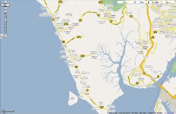
Getting there Tanjung Piai is located about 75km from Johor Bahru. Currently there is no direct bus service to the Tanjung Piai Johor National Park. Taxi service is available from Pontian bus station, in the town center, to Tanjung Piai's entry point in Sungai Belukang. Be sure to book your return passage back to town in advance with your cab driver. A full taxi of four passengers should cost around RM15.From Kuala Lumpur, take the North-South Expressway (NSE) south past Machap, then take the Simpang Rengam exit (Interchange 247) onto the highway headed for Tanjung Piai, via the Benut - Pontian - Kukup highways (Highway 96, Highway 5 and Highway 95). Once near Kukup, follow the sign boards leading you to Tanjung Piai.
By RoadFrom Kuala Lumpur, take the North South Highway (NSE) and take the Simpang Renggam exit (Interchange 247) via Benut to Pontian (trunk road 96 and 5). Sungai Peradin is located 5km away from the Jalan Pontian-Kukup junction (trunk road 95), and 10km from Pontian
ThereJust head south! After exiting the PLUS Tangkak interchange, head for Muar and from there continue down south using the Pontian coastal road.
Tanjung Piai Johor National Park is located in the Mukim of Serkat, Pontian, about 92km from Johor Baru.
From Johor Baru or Muar, head for Kukup. Just before Kukup, turn left and drive towards Kampung Serkat and Tanjung Piai. Follow signs to either Entry Point 1 or 2. The Sg Belukang entry (Entry Point 1) is open on Saturdays, Sundays and Public Holidays. Entry Point 2 at the Visitors Complex is open daily. Both counters are closed on Mondays.
For more details,
contact the park at 07-696 9712
Johor National Park Corporation at 07-223 7471
Web site
Map
More Pictures
Links
Kukup @ Pontian, Johor
Kukup is a small fishing village located about 40 kilometres southwest of Johor Bahru, in the district of Pontian, Johor, on theStrait of Malacca in Malaysia. It is famous for its open-air seafood restaurants built on stilts over the water.
Get there by
Bus
Take bus 96 from JB Lakin to Pontian Kecil, and to Kukup on a taxi.
Things to Do
Fishing
Cycling
Kampung visit
Kelong visit
Kukup Red Forest visit - Malaysia biggest mangrove swamp. There are at least 67 bird species and 27 mangrove species. Nature lovers will be pleased to know that the island, with 80ha of mudflats and dense foliage attracts all kinds of animals including birds, mudskippers, crab and wild boar.
Tanjung Piai, Johor is the Southernmost tip of Asia Continent. Best visit in September!
Food to eat
Fresh seafoods
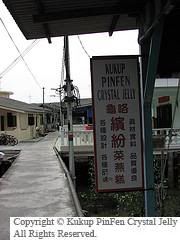
PinFen Crystal Jelly Call Auntie Tay Hwee Choo - +6076960341
Where to Stay
1)KUKUP WATER HOUSE Mr. Gay Kui Seng TEL: 07-6969220 OR H/P: 010-7131652
2)KUKUP VENICE HOLIDAY VILLA RESORTMr. Yeo Kean TeckTEL: 07-6961516
3)KUKUP FLOATING CHALETMr. Lee Kok PohTEL: 07-6960027, FAX:07-6969230
4)KUKUP GARDEN RESORTMr. Lim Cheng HockTEL: 07-6960431, 07-6871328
5)The Mangrove Floating ChaletMr. Lim Thiam HockTEL:07-6960461 HP: 019-7509111
6)Yee Jing Kukup Chalet: Evelyn +6590904110 (HP) - S$75/Adult and S$55/Child (with transport from SG) RM85/Adult and RM50/Child
6)Yee Jing Kukup Chalet: Evelyn +6590904110 (HP) - S$75/Adult and S$55/Child (with transport from SG) RM85/Adult and RM50/Child
Nearby getaway
Singapore
Tanjung Balai, Karimun, Indonesia by ferry.
Recommended Website
Subscribe to:
Posts (Atom)